Virginia packs an unusual amount of fly fishing into one state. The Blue Ridge and Allegheny highlands hold wild native brook trout streams and limestone spring creeks. Cold tailwaters below mountain dams grow large wild brown trout. Big warm rivers like the New and the South Fork Shenandoah are smallmouth bass water. And around the Washington suburbs, small stocked streams give city anglers a walk-in trout option close to home.
The Virginia Department of Wildlife Resources (DWR) counts more than 3,500 miles of trout streams in the state, including over 2,900 miles of wild trout water and about 600 miles of stocked trout water. That range is the point of this guide: no single rule, season, or fly covers all of it. Many of Virginia’s best-known trout waters carry special regulations that override the statewide defaults, and Shenandoah National Park runs under its own rules. Check the regulation for the specific water you plan to fish before you keep a fish, and check DWR’s current stocking schedule and park conditions before you travel.
What follows are the places that define Virginia fly fishing today: the limestone special-regulation water at Mossy Creek, the wild-trout tailwater of the Jackson River, native brook trout on the Rapidan, the brown-trout tailwater of the Smith River, wild rainbows on the South Fork Holston, smallmouth on the New River and the South Fork Shenandoah, and the close-to-home delayed-harvest streams and warmwater lake near the suburbs. Where a place has a rule that changes how you fish it, the rule is stated with the place.
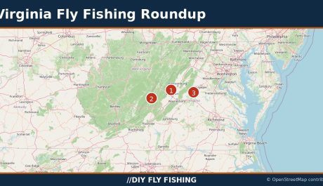
Virginia Trout Fishing Map

Get Directions to the Fishing Access Points shown above with the DIY Fly Fishing Map
Best Places to Fly Fish in Virginia
Mossy Creek
Mossy Creek is Virginia’s most famous fly fishing destination, in DWR’s own words: a classic limestone spring creek flowing through rolling farmland near Bridgewater, in Augusta County. Its spring-fed water stays cold through the hottest summer days and nearly unfrozen through winter, which makes it an excellent winter fishery. Brown trout are the reason anglers come here. The fishery is sustained by annual stocking of fingerling and advanced-fingerling browns, which grow fast in the food-rich water and take on striking yellow, brown, and crimson colors. Brook and rainbow trout turn up occasionally, but Mossy is, in DWR’s phrase, “the home of large brown trout.” Expect tough, technical fish in clear water full of aquatic vegetation, with swift runs and steep drop-offs.
Mossy Creek is a special-regulation water, and its rules are strict. Fishing is fly-fishing only. The limit is one trout per day, 20 inches or longer, for brown, brook, and rainbow trout. No wading is allowed, so fish must be approached cautiously from the steep banks. No camping, fires, picnicking, loitering, or dogs are allowed, and anglers must leave livestock, fences, and electric fence controls alone. Every angler must carry a free, signed landowner permission card in addition to a valid Virginia fishing license; permits can be obtained online through Go Outdoors Virginia or at the Verona Regional Office on weekdays. No trout license is required to fish Mossy Creek. The regulated section is a 4-mile portion of stream upstream from the Augusta/Rockingham county line to a sign at the confluence of Joseph’s Spring, just off Route 42 south of Bridgewater.
Access is tightly controlled, and the rules are part of the fishing. Mossy Creek flows through private land under a unique conservation easement agreement, and fishing it means following DWR’s access rules to the letter. No wading is allowed — you fish from the bank. A free signed landowner permit card is required, obtainable from DWR’s Verona office and other listed locations, and it must be carried along with a valid Virginia fishing license. No trout license is required. Parking is limited to the small lot on Route 613 (Kyles Mill Road) beside Mossy Creek Presbyterian Church; the lot on Mossy Creek Road/Iron Works Road is closed, and roughly 1,100 feet of the creek at Iron Works Road (State Route 809) is posted and may not be fished. No camping, fires, picnicking, loitering, or dogs are allowed along the creek.
Jackson River Tailwater Below Gathright Dam
The Jackson River tailwater below Gathright Dam is, in DWR’s caption, “considered by many to be the premier wild trout tailwater in Virginia.” Deep riffles and rock bluffs mark the river as it runs some 18 miles of legally navigable water to Covington, holding wild rainbow trout, wild brown trout, smallmouth bass, rock bass, and redbreast sunfish. This is a big-fish tailwater fished with the slot rules below, not a put-and-take stream, and it rewards anglers who can read deep, rocky water and present flies precisely.
The special regulations for the section from Gathright Dam downstream to the Westvaco Dam at Covington are exact, and worth learning before you rig up: no rainbow trout 12 to 16 inches may be kept; no brown trout less than 20 inches may be kept; the creel limit is 4 trout per day combined (rainbow and brown), of which only 1 may be a brown trout over 20 inches; all rainbow trout between 12 and 16 inches and all brown trout under 20 inches must be released immediately. The 7-inch statewide minimum size limit does not apply to rainbow trout in this section. Bait is allowed, and there are no gear restrictions between Gathright Dam and the water treatment plant in Covington.
Do not confuse this tailwater with the separate Jackson River special-regulation section upstream in Bath County, above Lake Moomaw near Hidden Valley — a 3-mile, foot-access-only reach with a 16-inch minimum, a 2-fish daily limit, and artificial lures only, where a trout license is required October 1 through June 15. That section’s rules do not apply to the tailwater. For the tailwater itself, no tailwater-specific trout-license requirement or closed season is stated in the current special-regulation listing; check DWR licensing before you go rather than assuming either way.
Access is from the public sites DWR names below Gathright Dam, including Gathright Dam, Johnson Springs, Smith Bridge, Indian Draft, Petticoat Junction, the Water Plant, City Park, Island Ford, Low Moor, Dabney Lancaster, and Lick Run. Use those public sites and respect posted water: riverfront landowners have brought successful civil trespass claims against anglers in two portions of the river highlighted on DWR’s map, so check the DWR Jackson River page and its map before wading or fishing outside a public access site. Flows below the dam are regulated releases, so check the current release schedule before wading.
Rapidan River in Shenandoah National Park
The Rapidan is the headwater brook trout river of Shenandoah National Park, and the most storied native-trout water in the state. Small, swift headwater streams grade into a larger, boulder-strewn river of cascading whitewater and quiet pools, all of it wild — no fish are stocked anywhere in the park, and the Rapidan’s brook trout reproduce naturally. DWR puts the average Rapidan brook trout at five to eight inches, though some of the deeper holes in the middle to lower reaches hold fish of 12 inches or more. The river’s name reaches back to President Herbert Hoover’s Rapidan Camp, where Mill Prong and Laurel Prong combine to form the Rapidan. The surrounding Rapidan Wildlife Management Area, which borders the park on the east, holds the same exceptional native fishery in the Rapidan and Conway rivers.
The Rapidan is catch-and-release water, inside the park and within the Rapidan Wildlife Management Area: no trout may be possessed on the Rapidan or its tributaries within those boundaries. Park rules govern how you fish it: single-point-hook artificial lures only (dropper flies with multiple single hooks in a series are permitted), no organic bait in your possession while fishing, one line per person, and no snagging. Anglers 16 and older need a valid Virginia fishing license; no state trout license and no separate park permit are required. One rule catches Rapidan anglers out, so learn it before you go: brook trout must be released, but a captured brown, rainbow, or tiger trout must never be released alive in the park — fish under the 7-inch state minimum, and any brown or rainbow caught in a stream closed to harvest, must be killed and disposed of out of sight of any stream, road, or trail, because non-native trout compete directly with the native brook trout the park is protecting. The superintendent can also restrict fishing when high temperatures or low water make it unsafe for the fish, so check current park conditions before traveling.
Reach the headwaters from Skyline Drive at Milam Gap (mile 52.8), taking the Appalachian Trail to the blue-blazed Mill Prong Trail toward Rapidan Camp — the National Park Service describes that hike as a 4-mile round trip of moderate difficulty. From the east, the lower boundary is reached by Route 662 from Graves Mill and Route 649 from Criglersville, and the Rapidan Wildlife Management Area tract by State Route 649 (Quaker Run Road) beyond the state-maintained portion, where the road turns to dirt, narrows, and is not maintained to state standards; DWR recommends a four-wheel-drive vehicle. No primary source states a best season or hatch calendar for the Rapidan specifically, and DWR describes spring and summer as the busy period — treat any stronger seasonal claim you read elsewhere as unverified. For the full park rules, start with the National Park Service fishing page for Shenandoah.
Shenandoah National Park
Beyond the Rapidan, Shenandoah National Park holds more than 90 mountain streams, over 70 of which contain fish, most of them native brook trout. The park’s streams feed three of Virginia’s ten major drainages — the Potomac, Rappahannock, and James — and they are fished the way mountain streams have always been fished: on foot, with a light rod, working pocket water and plunge pools under a hardwood and hemlock canopy. Because no fish are stocked, every trout you catch is wild, and the fishery depends entirely on natural reproduction. That is why the park’s rules are stricter than the state’s, and why they control wherever they differ.
Know the park rules before you enter: all park streams are open to catch-and-release fishing, and harvest is permitted only on a limited list of streams that the park updates annually — check the park’s current list before keeping any fish, and do not rely on a printed list from a prior year. On streams open to harvest, the creel limit is 6 trout per day with a 9-inch minimum for brook trout and a 7-inch minimum for brown and rainbow trout. Everywhere in the park, only single-point-hook artificial lures may be used, no organic bait of any kind may be in your possession while fishing, and only one line per person is allowed. Anglers 16 and older need a valid Virginia fishing license; no trout license and no park permit are required. For the wider park — more streams, flies, and trip planning — see the Shenandoah National Park guide, and keep the rules themselves sourced to the Park Service and DWR pages linked here.
Smith River Below Philpott Dam
The Smith River below Philpott Dam is one of the state’s most unusual trout fisheries: a coldwater tailwater whose releases keep miles of river fishable all year, holding an outstanding wild brown trout population alongside stocked rainbows. DWR describes an abundance of brown trout 6 to 12 inches in the upper river near the dam, with abundance falling but size rising downstream; brown trout 12 to 18 inches are common below Martinsville Dam, and a brown over 20 inches is possible. Downstream of the Marrowbone access point the browns fade and smallmouth bass, rock bass, and sunfish take over as the river warms toward North Carolina.
From Philpott Dam downstream about 31 miles to the State Route 636 crossing (Mitchell Bridge) is designated special-regulation brown trout water: all brown trout between 10 and 24 inches must be released immediately, only one brown trout over 24 inches may be kept per day, the minimum length for all trout is 7 inches, and the combined creel limit is 6 trout per day. Bait and any combination of artificial lures are allowed throughout the section. Two put-and-take stocked sections sit inside that special-regulation reach, and the brown-trout slot still applies inside them: a 3.3-mile Category B section from Philpott Dam to the Town Creek confluence, stocked with rainbow trout 5 times from October 1 through June 15, and a 9.5-mile Category A section from North Bassett to below Fieldale, stocked 8 times in the same window. A trout license is required in those put-and-take sections October 1 through June 15.
Nine public access points line the river, reached from State Route 57 and secondary routes off it, operated by Henry County Parks and Recreation and the Dan River Basin Association. Water levels fluctuate daily with hydroelectric generation from Philpott Dam — call 276-629-2432 for the generation schedule before fishing or paddling. Check the DWR Smith River page for access details and the current picture.
South Fork Holston River
First, a naming caution that saves a wasted drive: the Virginia river is the South Fork Holston River, in Smyth and Washington counties in the state’s far southwest. It is not the famous South Holston tailwater below South Holston Dam in Tennessee, and the reservoir creel rules you may find under the “South Holston” name do not apply to this river. What Virginia has is one of the state’s greatest wild rainbow trout streams, in DWR’s words — some 40 miles of limestone-influenced freestone flowing through Jefferson National Forest and private land beside Mount Rogers to South Holston Lake, its countless springs holding temperatures steadier than surrounding waters: coldest in summer, warmest in winter. The population reproduces naturally along the river’s entire length. The average fish is a 6- to 10-inch wild rainbow; brown trout are far fewer but carry real trophy potential.
The upper public water is walk-and-wade water with three distinct regulation sections, and they must not be merged. The uppermost roughly four-mile reach, from 500 feet above the dam at the Buller Fish Cultural Station upstream to the upper Jefferson National Forest boundary above the Appalachian Trail crossing, allows single-hook artificial lures only, with a creel limit of 2 fish per day and a 16-inch minimum size. Between the Buller dam and the special-regulation area sits a short, 500-foot put-and-take stretch. The mile of water below the dam to the lower boundary of the hatchery property is catch-and-release only, single-hook artificial lures only. Below Buller, three more Category A put-and-take sections — near Thomas Bridge, from Red Stone Road to Hiler Bridge, and from Chilhowie Riverside School to Saint Clair’s Bottom — receive eight stockings between October 1 and June 15. Reach the upper river from Interstate 81 exit 45 at Marion, south on Highway 16 toward Sugar Grove, then Teas Road to Route 650 past the Buller station.
The lower river is a different proposition: DWR’s float descriptions for the Washington County reaches repeatedly note little to no public access, with launches and takeouts on private land requiring landowner permission. Do not plan a lower-river float as public water. The best float window, per DWR, is late spring and early summer when flows are higher. Winter is a fine time on the upper river too — DWR notes sporadic afternoon hatches of blue quill and blue-winged olive mayflies, with stoneflies, midges, and mayfly nymphs subsurface. See the DWR South Fork Holston page for section boundaries and access before you go.
New River Smallmouth Bass
The New River runs north — against the grain of the East Coast — for some 160 miles through Grayson, Carroll, Wythe, Pulaski, Montgomery, and Giles counties before it becomes Bluestone Lake in West Virginia. DWR calls it one of the best fishing rivers in Virginia, rivaling the James and Rappahannock, and it supports outstanding populations of just about every major freshwater game fish in the state. Smallmouth bass are by far the most abundant black bass in the river, but largemouth and spotted bass, rock bass, striped and hybrid striped bass, muskellunge, walleye, black crappie, channel and flathead catfish, yellow perch, and redbreast sunfish all live here. State records for muskellunge, smallmouth bass, and walleye have all come from the New. March, April, and May are DWR’s top months for trophy smallmouth, with good numbers of trophies also caught in July, August, and September, and anglers should do well year-round with anything that mimics a crayfish.
The bass slot rule governs the whole Virginia river and must be in every angler’s head before the first cast: from Fields Dam in Grayson County downstream to the Virginia–West Virginia state line — including the tributary reaches DWR names, and excluding Claytor Lake — no largemouth or smallmouth bass 14 to 22 inches may be kept, only 1 per day longer than 22 inches, with a 5-per-day aggregate limit. DWR’s 2026 forecast gives an honest, current picture: the upper river (Mouth of Wilson to Allisonia) produced 924 smallmouth in spring surveys with 25 percent over 11 inches and strong numbers of 7-inch fish coming; the lower river (Claytor Dam to the state line) ran slightly above its 20-year average for fish over 7 inches, with catch rates for smallmouth over 17 inches at an all-time high in 2025, best at Eggleston, Rich Creek, Whitethorne, and Clendenin Shoals.
The New is a float river first. DWR lists some 20 named float segments with mileages from Mouth of Wilson to Glen Lyn, and numerous department boat ramps including new facilities at Byllesby, Austinville, and Pembroke; plan on about an hour per mile under normal conditions if you plan to fish. Five dams interrupt the river in Virginia, with portages of varying difficulty and no portage around Claytor Dam, and dam releases can raise the water suddenly — be ready to move ashore if you notice a sudden rise. Wade fishing is practical mainly in low-water summer conditions on the upper reaches. The New River Trail State Park parallels the river for more than 50 miles and gives bank-side access to some reaches. Check the DWR New River page for segments, ramps, and the muskie and walleye exceptions that apply in different reaches.
Shenandoah River, South Fork
The South Fork Shenandoah begins where the North River and South River meet near Port Republic and flows 97 miles north to Front Royal, where it joins the North Fork. It is Virginia’s classic smallmouth numbers river: a wide, low-gradient stream averaging about 100 feet across, with Class I–II rapids and three low-head hydropower dams. DWR describes it as a numbers fishery rather than a trophy water — but fish upwards of 20 inches can be found, the river ranked third statewide for trophy-smallmouth citations in 2025, and 3 percent of the smallmouth in DWR’s fall 2025 sampling measured 17 inches and up. Smallmouth, largemouth, sunfish, crappie, muskellunge, catfish, and carp all live here. DWR’s 2025 fall sampling collected smallmouth at 72.2 fish per hour across nine sites — below the long-term average after three straight years of very low spawning success from extreme weather. Expect plenty of action and honest numbers, not a promise of the state’s highest catch rate.
Smallmouth fishing is year-round here — DWR is explicit that anglers should not limit themselves to the warmer months, and some of the larger fish are caught in the colder months. Twenty public access points line the river, supporting floats of many lengths; the Port Republic to Island Ford float runs 10 miles and makes a long day. Most bordering land is private outside the access points and small National Forest sections, so use the access points and wade the riffles where access allows. The slot limit applies: 5 black bass (smallmouth and largemouth) per day, and no bass 11 to 14 inches may be harvested. The Port Republic access site, at the confluence of the North and South rivers, has parking for up to 25 vehicles and a sloping gravel launch for kayaks, canoes, paddleboards, and small john-boats, with no motorboat ramp.
Accotink Creek
Accotink Creek is Fairfax County’s delayed-harvest trout water — a 3.1-mile reach from King Arthur Road downstream to Route 620 (Braddock Road), reached primarily through the Fairfax County Park Authority’s Wakefield Park facility off Braddock Road, near Annandale. It is walk-in, suburban water: a small stream you can fish for a few hours, reached by car, in one of the most densely populated corners of the state. That accessibility is the point. The delayed-harvest rules are the fishing: from October 1 through May 31, only artificial lures may be used, no trout may be in possession (catch and release only), and no bait may be in possession while fishing; a trout license is required October 1 through June 15. From June 1 through September 30, those three restrictions do not apply and the water fishes like any other designated stocked trout water. Check DWR’s daily stocking schedule before you go — stocking pauses when flows are too low, and no primary source confirms which trout species are stocked here or how often, so this guide does not assert either.
Holmes Run
Holmes Run is the other Fairfax County delayed-harvest water, a 1.2-mile reach from the Lake Barcroft Dam downstream to a sign at the Alexandria city line, with a trail following and sometimes crossing the stream from the parking lot off Columbia Pike (Route 244). Like Accotink, it is suburban walk-in water — a small creek in the middle of a busy area, offering a few hours of solitude and fishing a short drive from the city. The same delayed-harvest rules apply: October 1 through May 31, artificial lures only, catch and release only, no bait in possession, with a trout license required October 1 through June 15; general designated-stocked-water rules apply June 1 through September 30. Which species are stocked and how often is not confirmed in a primary source checked for this guide, so neither is asserted here. Check the DWR delayed-harvest waters page for both reaches before fishing either one.
Lake Brittle
Lake Brittle is the warmwater counterpoint in this guide: a 77-acre department-owned lake in Fauquier County, just east of Warrenton and southeast of New Baltimore off Routes 29/15, reached by Route 600 east to Route 793. It is not a trout lake — DWR’s species checklist marks trout as absent — and that is worth stating plainly, because the older version of this guide left the impression of a trout option. The lake supports largemouth bass, bluegill and redear sunfish, black crappie, and channel catfish as its main targets, plus walleye/saugeye and flathead catfish; northern snakehead, first documented in 2015 and apparently self-sustaining from illegal stocking, carry no length or bag limits and DWR encourages anglers to harvest every one caught. Expect heavy fishing pressure: the lake sits only about thirty miles from the Beltway, and DWR says so directly.
Fish it with the lake’s rules in mind. There is a 12- to 15-inch slot limit on largemouth bass — all bass in the slot must be released immediately unharmed, and anglers may harvest five bass per day under 12 inches or over 15 inches or any combination of the two. Walleye carry an 18-inch minimum and a 5-per-day limit; sunfish have no size limit with a 50-per-day combined limit; channel catfish run 8 per day with a 15-inch minimum; black crappie have no size limit with a 25-per-day limit. Access is by boat ramp and fishing pier with plenty of shoreline, open year-round with 24-hour private boat access; electric motors only — gasoline motors, gill nets, and seines are prohibited — and wading while fishing is not permitted. Camping, swimming, sailboats, hunting, trotlines, and prize fishing tournaments are prohibited. Visitors 17 and older need a DWR Access Permit unless they hold a valid Virginia hunting, freshwater fishing, or trapping license or a current Virginia boat registration. The concession stand is closed until further notice. See the DWR Lake Brittle page for the current picture.
Understanding Virginia’s Trout-Water Categories
Virginia’s general trout rule is simple: a year-round season, a daily limit of 6 trout, and no fish under 7 inches. The complication is that the general rule is only the default. DWR layers several programs on top of it, and the program that applies to your water decides what you can keep, what you can fish with, and whether you need a trout license. Learn the categories and the rest of Virginia’s regulations get much easier.
Designated stocked trout waters are the put-and-take backbone: waters stocked with catchable-sized trout and listed in DWR’s annual Trout Stocking Plan. They count as designated stocked waters only from October 1 through June 15, and a trout license is required during that window; from June 16 through September 30 no trout license is required. Angling hours run from 5:00 a.m. until one hour after sunset. Only one rod, one line, and one baited hook may be used (a treble hook counts as one hook), though any combination of artificial lures is allowed. Once a trout goes into your creel it counts against your limit and may not be released. Stocking runs October 1 through May 31, with Category A waters stocked 8 times, Category B 5 times, and Category C 3 times. DWR’s 2026–2031 Stocked Trout Management Plan includes a 35 percent reduction in stocking statewide, so historic stocking totals should not be treated as current promises.
Delayed-harvest waters, like Accotink Creek and Holmes Run above, flip to catch-and-release from October 1 through May 31: artificial lures only, no trout in possession, no bait in possession, with a trout license required October 1 through June 15. From June 1 through September 30 the restrictions lift and the water fishes under general designated-stocked-water rules. Urban program waters run a different window — designated stocked waters November 1 through April 30 only, with a 4-per-day creel limit and the same 7-inch minimum. Youth-only stocked waters run April 1 through June 15 for anglers 15 and younger, with a 3-fish daily limit. Trout Heritage waters close for one day only: the Friday before the first Saturday in April, reopening at 9:00 a.m. that Saturday. Fee fishing areas — Clinch Mountain, Crooked Creek, and Douthat State Park — require a daily permit instead of a trout license during their fee seasons and are closed five days before opening day; Douthat also runs a fall fee season from September 15 through October 31.
Special-regulation waters are the exception list that covers most of the famous water in this guide: higher minimum sizes, lower creels, fly-only or artificial-only sections, and catch-and-release-only sections, each spelled out water by water on DWR’s special-regulation listing. Mossy Creek (20-inch, 1 fish, fly-only), the Jackson tailwater (slot rules), the Smith River brown-trout slot, the South Fork Holston sections, and the Rapidan’s catch-and-release rule all live on that list. The dividing line is not wild versus stocked — DWR applies special restrictions to certain wild waters and to several types of stocked streams alike. Before you keep a fish anywhere in Virginia, check that water’s entry on the special-regulation trout waters listing and the current DWR regulations.
Best Time to Fly Fish in Virginia
Trout season in Virginia is year-round, and the honest seasonal story is about conditions, not openers. Spring is the big hatch season: DWR describes March, April, and May as well known for hatches and dry-fly fishing in the Mount Rogers highlands, with insect activity swinging into action and all standard tactics applicable. Summer brings low, clear flows, and trout get wary — long leaders, careful approaches, and terrestrial imitations (ants, beetles, grasshoppers, inchworms) from June through October do the work, while high-elevation streams that start above 4,500 feet stay cool longest and can offer some of the year’s best dry-fly fishing. Fall cools the water, trout feed heavily, and it brings the best chance at a trophy brown trout preparing to spawn — large streamers are the call. Winter is nymph water, with tiny caddis larvae through giant black stonefly nymphs, broken by occasional blue-winged olive hatches on a run of warm, sunny late-winter days. Tailwaters fish all year on cold releases, and smallmouth rivers fish year-round with the trophy window in March through May.
No DWR statewide hatch chart was found for this guide, so this guide does not print a month-by-month hatch table as if the agency had published one. Use the seasonal shape above, watch local conditions, and check DWR’s stocking schedule and the park’s current conditions before a trip — stocking runs October through May, flows on the Northern Virginia delayed-harvest streams can pause stocking when they run low, and Shenandoah National Park can suspend fishing when heat and low water stress the brook trout.
Essential Gear and Best Flies for Virginia
One rod does not cover Virginia. A 9-foot 4- or 5-weight handles the mountain brook trout streams, the Rapidan, and the delayed-harvest creeks. Mossy Creek’s technical browns and the Jackson and Smith tailwaters want a 9-foot 5-weight with long, fine leaders and careful presentations — and on Mossy, bank fishing only, since wading is prohibited. Smallmouth water — the New, the South Fork Shenandoah — fishes best with a 6- or 7-weight, a stout leader, and crayfish and streamer patterns, fished from a boat or while wading riffles. Lake Brittle’s bass and panfish suit a 5- or 6-weight with poppers and small streamers from the bank, pier, or an electric-motor boat. Everywhere in the mountains, carry the National Forest Permit rules in mind (see Regulations below) and wade with a staff on slick freestone; on the tailwaters, check generation schedules before stepping in.
For flies, follow the seasonal shape DWR describes rather than a fixed list. Blue-winged olives and blue quills show in late winter and winter afternoons; spring brings the mayfly, stonefly, and caddis hatches; summer belongs to terrestrials — ants, beetles, grasshoppers, inchworms — fished tight to the banks; fall belongs to large streamers like muddler minnows, woolly buggers, and woolhead sculpins for spawning-run browns. On Mossy Creek, DWR notes blue-winged olive, trico, and sulphur hatches with a switch to terrestrials by mid-summer, fished with the patience the creek’s educated browns demand. In Shenandoah National Park, remember the gear rule is part of the fly selection: single-point-hook artificial lures only, with dropper-fly rigs permitted, and no bait of any kind in your possession while fishing. Carry nymphs year-round, because subsurface food dominates the trout’s diet for much of the year.
Virginia Fishing Regulations and Licenses
Virginia’s licensing is straightforward once the trout-license rule clicks. A Virginia freshwater fishing license is required for anglers 16 and older; residents and nonresidents under 16 are exempt from both the fishing license and the trout license. The trout license is an add-on, required only when fishing designated stocked trout waters from October 1 through June 15 — not for wild-trout-only waters, not from June 16 through September 30, and not in Shenandoah National Park. Water-specific exceptions run both ways: a trout license is required on the special-regulation Jackson River section in Bath County in season, while Mossy Creek does not require one. Licenses are valid one year from purchase and are sold through Go Outdoors Virginia, by phone, and in person from license agents and some circuit court clerks.
Fees below are the schedule effective October 1, 2026, after DWR’s 2026 fee increase — the pre-October figures still shown in some guides are stale, and the nonresident trout license in particular is no longer the old $23. Resident: one-year freshwater fishing $27; trout license (October 1–June 15) $27; senior (65 and older) annual freshwater $8; five consecutive days freshwater $18; Sportsman’s License, which includes the trout license, $129. Nonresident: one-year freshwater fishing $71; trout license (October 1–June 15) $47; one-day freshwater $19; five consecutive days freshwater $35. The daily permit for the fee fishing areas is $12. Verify current fees at purchase through Go Outdoors Virginia, since fees change. A National Forest Permit is additionally required when fishing on National Forest lands, with exceptions including residents under 16 and over 65 and nonresidents under 16, and excepted waters including the Jackson River below Gathright Dam and the North and South Forks of the Shenandoah — no dollar figure is stated here because the permit’s fee could not be confirmed in a current primary source; check at purchase. A State Forest Use Permit is required for anglers 16 and older on state forest lands. Carry your license (electronic, printed, or hard card) and show it on request.
Three rule summaries to carry with you. First, the general trout limit — 6 per day, 7-inch minimum, year-round — is the default, and special-regulation waters override it water by water; the Rapidan is catch-and-release, Mossy Creek is 1 fish at 20 inches fly-only, the Jackson tailwater and Smith River run slot rules, and the South Fork Holston sections run 16-inch/2-fish and catch-and-release rules. Second, Shenandoah National Park rules supersede state rules: catch-and-release by default, harvest only on the park’s annually updated list, single-point artificial lures only, no bait in possession, never release a brown, rainbow, or tiger trout alive, and check current park conditions for temporary closures. Third, designated stocked waters have their own conduct rules — 5:00 a.m. to one hour after sunset, one rod, one line, one baited hook, no culling after the limit — and delayed-harvest, urban, youth-only, heritage, and fee-area waters each add their own windows. When in doubt, the DWR fishing regulations pages and the current eRegulations guide are the deciding sources, not this guide.
Planning a Virginia Fly Fishing Trip
Base yourself by the water, not by the interstate. Bridgewater and Harrisonburg put Mossy Creek and the Shenandoah Valley within easy reach; Covington serves the Jackson River tailwater; Front Royal and Luray serve Shenandoah National Park and the South Fork Shenandoah; Martinsville serves the Smith River; Marion serves the South Fork Holston; Blacksburg and Radford serve the New River; Fairfax and Alexandria serve Accotink Creek and Holmes Run; Warrenton serves Lake Brittle. Most of the mountain and tailwater fishing is a day trip from those towns, and the park’s Skyline Drive gives access to dozens of streams from a single road — at the cost of entrance fees and, on busy weekends, company.
Before any trip, run three checks. First, DWR’s daily trout stocking schedule and the annual Trout Stocking Plan, for which designated waters were stocked and when — and whether low flows have paused stocking on the urban streams. Second, the regulation for your exact water on DWR’s special-regulation listing, since the general limit so often does not apply. Third, current conditions: Shenandoah National Park alerts for fishing suspensions, dam generation schedules for the Jackson and Smith tailwaters, and river flows everywhere after heavy rain. Much of Virginia’s best trout water runs through private land or National Forest, so know whose land you are on, use public access points, get landowner permission where the rules require it, and leave gates, fences, and livestock alone. Virginia rewards the angler who does that homework: wild brook trout in a mountain headwater in the morning, smallmouth on a big river in the afternoon, and a limestone spring creek full of large browns the next day, all within a few hours’ drive.
Virginia is not a state you finish in one trip, and that is the point. Start with the water that matches the season and the fish you want — spring hatches in the mountains, summer smallmouth on the New, fall browns on the tailwaters, winter browns on Mossy Creek — learn that water’s rules cold, and let each trip teach you the next one. The map above and the DIY Fly Fishing map will get you to the access points; DWR’s regulations will keep you legal once you are there.