Arkansas Fly Fishing 11 min read
Little Red River (Greers Ferry Tailwater), Arkansas — Fly Fishing Guide

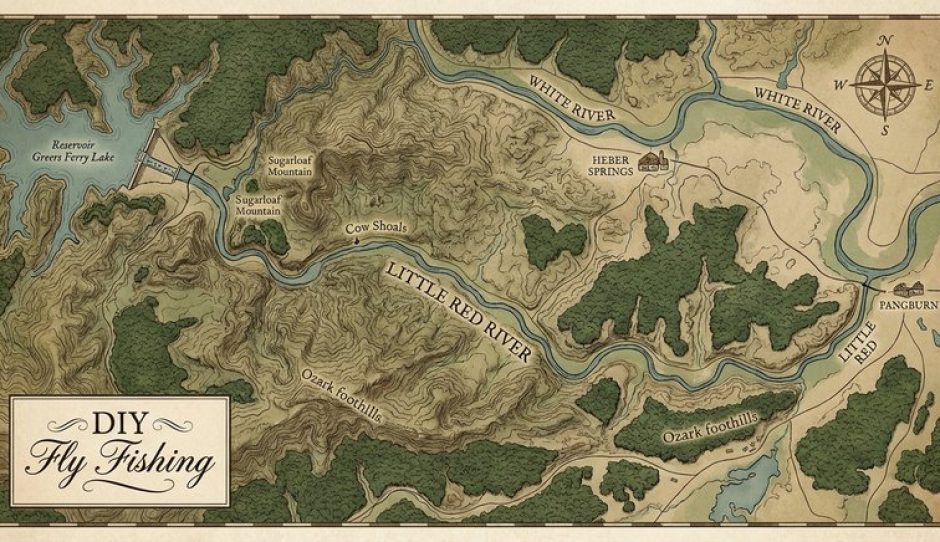
The Little Red River below Greers Ferry Dam does not fish like a simple stocked stream, even though stocked rainbows are part of the picture. This is a big, cold tailwater where wild brown trout reproduce on their own, where a morning can start with fish rising to tiny midges and end with you watching the water because generation is about to change everything.
That is the real skill here. Learning the Little Red is less about a secret fly and more about reading a schedule, picking a shoal you can wade safely at low water, and knowing when to get out. Do that, and you have about 30 miles of trout water in central Arkansas, from the catch-and-release water in John F. Kennedy Park below the dam to the shoals downstream toward Pangburn. It anchors our wider coverage of Arkansas fly fishing.
Plan It With the DIY Fly Fishing App
Take this guide on the water — get turn-by-turn directions to every access point below with the DIY Fly Fishing app:


About the Little Red River
Greers Ferry Dam, in Cleburne County, was built by the U.S. Army Corps of Engineers for flood control and hydroelectric power. Commercial power generation began in July 1964. Cold discharge below the dam created coldwater habitat that was less suitable for native sportfish, and the Arkansas Game and Fish Commission (AGFC) began stocking trout in 1966 to mitigate the loss.
Rainbow trout were stocked first, in 1966. Brown trout were introduced in 1977 and established a self-sustaining wild population. They are not maintained by stocking the way rainbows are — they spawn and grow in the river, and they can grow very large.
The Little Red is home to the current 4-pound-test line-class world-record brown trout: 40 pounds, 4 ounces, caught in 1992, as AGFC states it. Note the wording — a line-class record, not a claim that no bigger brown has ever been caught anywhere since.
The stocked side is supported by the Greers Ferry National Fish Hatchery, operated by the U.S. Fish and Wildlife Service just below the dam. Established in 1965, it began trout production in 1966 with rainbow trout and added brook trout in the 1990s. It produces rainbow and brook trout for tailwaters in Arkansas and eastern Oklahoma — around 700,000 trout annually, in partnership with state agencies. Rainbows here are mainly a stocked fishery, browns mainly a wild one. Fish for them differently.
Heber Springs, right below Greers Ferry Lake and the dam, is your main base, with the closest lodging and services to the upper river, the hatchery, and JFK Park. Downstream, a string of shoals — Cow Shoals, Libby Shoals, Mossy Shoals and others — runs toward Pangburn: tighter near the dam, broader downstream, with long pools that fish best from a boat when the water is up.
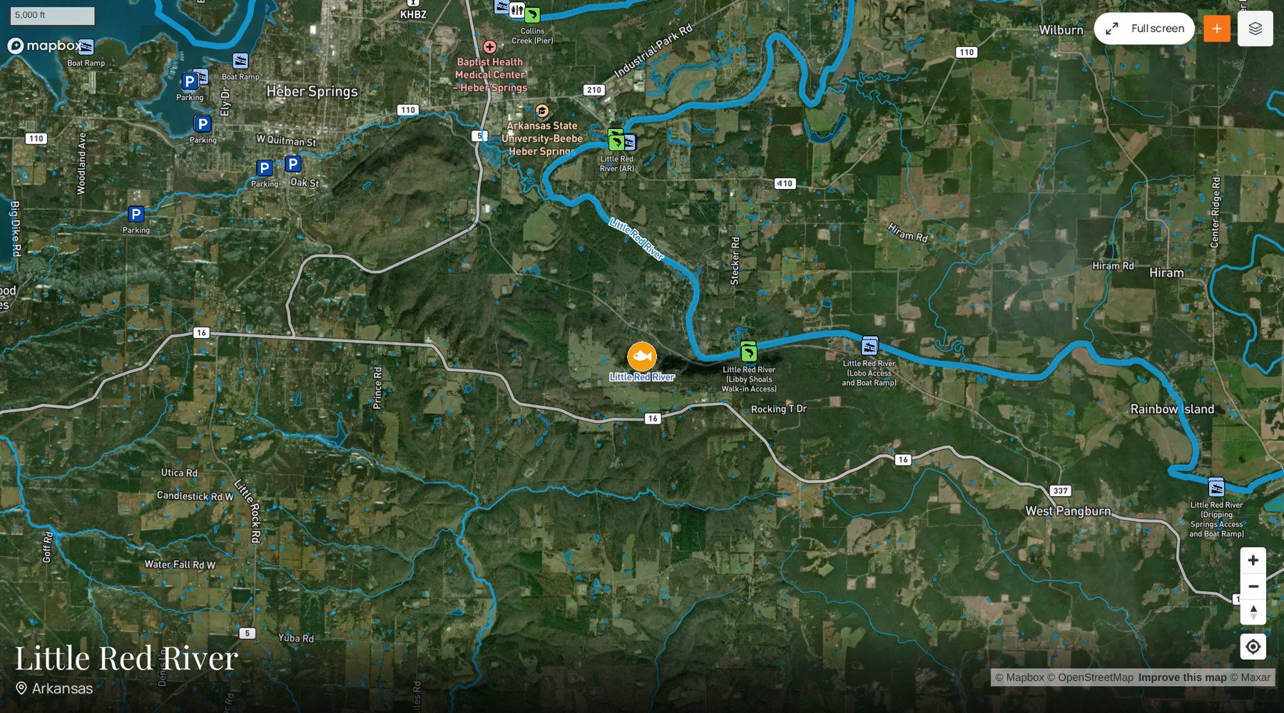
Little Red River Map and Fishing Access Sites
Plan It With the DIY Fly Fishing App
Every access point shown on the map above is in the free DIY Fly Fishing app, with turn-by-turn directions to each one — plus hatch reports and stream conditions for the Little Red River.
See the Little Red River destination page on the DIY Fly Fishing Guide site for its hatch chart, full access list and stream data.
Our access database lists 28 access points for the Little Red River. Generation, season, and whether you are wading or floating should decide where you put in. Named points include JFK Park Access and Boat Ramp, Barnett Access, Dripping Springs Access, Cow Shoals Walk-in Access, and Libby Shoals Walk-in Access.
Two cautions belong up front. First, there is no fishing, boating, or wading within 100 yards of Greers Ferry Dam — a regulation, not a suggestion. Second, Collins Creek, in JFK Park, appears in listings as Collins Creek Access, but do not treat it as general access. It is a separate small catch-and-release stream restricted to youths and mobility-impaired anglers, with its own rules below. If you are an adult fishing on your own, fish the main river.
Best Places to Fish the Little Red River
Start at the top. The upper river fishes well on foot at low generation, the middle shoals are classic wade water, and the lower river rewards a boat. Pick water you can leave quickly if generation starts.
JFK Park and the JFK Catch-and-Release Area
This is the easiest first stop, and a good place to learn how the river behaves. The JFK Catch-and-Release Area runs from 100 yards below the dam about half a mile downstream to the last Greers Ferry National Fish Hatchery effluent outfall in John F. Kennedy Park, as signed. Every trout must be released, and only artificial lures or flies with barbless hooks may be used.
Fish it when generation is off, working edges, seams, and soft water. It is popular, so go early — in return you get convenience, clear rules, and a chance to see how Little Red trout feed.
Cow Shoals
Cow Shoals, reached by walk-in access, is the name most visiting fly anglers learn first after JFK. The Cow Shoals Catch-and-Release Area runs from the head of Cow Shoals to the mouth of Canoe Creek, as signed. All trout must be released, only artificial lures with a single barbless hooking point per pole may be used, and the area is closed to night fishing from October 1 through December 31.
That fall closure lines up with spawning season. Browns move onto the shoals in fall; you may see the pale, cleared patches of redds — the nests. Do not wade through redds or cast to actively spawning fish. Target the fish feeding below the shoals instead, and wade carefully: stay shallow, use a staff, and have your exit in mind.
Barnett Access and Libby Shoals
Barnett Access gives you another upper-to-middle-river entry, in the reach long associated with the old Swinging Bridge name on local maps. Use it as a wading base at low water, not as a start to a long downstream walk you cannot reverse. Fish riffle heads first, then deeper runs. Stocked rainbows hold where the food lands; browns hold where they can ambush it — under cut banks, behind boulders, along darker edges.
Libby Shoals Walk-in Access offers shoal fishing without the full Cow Shoals crowd: riffles, a deeper slot below, and fish spread between them. On low, clear water, lengthen your leader and make the first cast count. On a grey day, fish a streamer through deeper side channels.
Dripping Springs, Mossy Shoals, and the Water Toward Pangburn
Dripping Springs Access opens the downstream core water. Pools lengthen, fish spread out, and a boat becomes more useful. Nymph the shoal, then work the pool below it. Generation reaches you later here than at the dam — later does not mean never. Check the schedule for the whole day.
The Mossy Shoals Catch-and-Release Area runs from the head of Dunham Shoals to the end of Mossy Shoals, as signed: all trout released, artificial lures or flies only, barbless, no chumming. Fish it carefully — small nymphs and midges in the seams, streamers along deeper edges at low light.
Best Time to Fish the Little Red River
The Little Red is a year-round trout fishery. The dam keeps the upper river cold in summer and fishable through winter. Your season choice is about which version of the river you want.
Fall is the season most anglers plan around. Browns move for spawning and rainbows feed hard below the shoals. Be most careful now: watch for redds from October onward, respect the Cow Shoals night closure, and release big browns quickly.
Winter is quiet and technical. Crowds thin, midges matter, and a small nymph fished deep and slow in a pool outfishes almost everything else. Dress for standing in cold water, not for the parking-lot air temperature.
Spring brings stronger insect activity and active fish all day — a good first-trip season, with nymphs in the morning, rising fish when mayflies or caddis show, and streamers in deeper water.
Summer is made by generation and timing. Fish early, fish the low-water windows, and use high water only from a boat with an experienced hand on the oars — or wait for it to drop. Never try to beat rising water on foot.
In every season, the best time of day is the low-generation window. On this river, the schedule is the hatch chart, the wading forecast, and the safety plan in one.
Stream Flow and Current Conditions
Use three sources together. Do not rely on how the river looked last week, or on a single gauge.
First, generation. The Southwestern Power Administration (SWPA) posts the projected generation schedule for Greers Ferry — project code GFD on the SWPA schedule — and the U.S. Army Corps of Engineers Little Rock District publishes real-time Greers Ferry Lake and outflow data. AGFC’s weekly report gives the same advice: check the Corps’ Little Rock District outflow information, check SWPA for the forecast generation schedule, and check the USACE Little Rock app for the projected schedule. Schedules change during the day. Check again the morning you fish.
Second, the USGS gauges downstream: USGS 07076000, Little Red River near Heber Springs; USGS 07076517, Little Red River near Dewey, AR; and USGS 07076634, Little Red River at Judsonia, AR. Read them in order, from the dam down. A rise at Heber Springs will reach Dewey and Judsonia later. This guide deliberately gives no flow number to plan around — a printed number is stale the moment generation changes. Use the live readings.
Third, your own eyes. If the water is rising and pushing debris, get out. Set a mark on the bank when you start — a rock at the waterline — and check it often. If it disappears, leave.
Best Flies for the Little Red River
You do not need a huge box. You need small flies fished well, plus a few bigger patterns for browns.
Midges, all year. Zebra Midges and slim midge pupa in black, red, and olive, sizes 18–22, are the backbone fly. Fish them deep under an indicator in pools and at the tails of shoals. When trout are rising in winter and will not take a mayfly, they are often taking midges — drop to your smallest pattern and lengthen the tippet.
Sowbugs and scuds. Grey and olive imitations, sizes 14–18, are reliable searching nymphs, especially near the dam and along rocky edges. Fish them on the bottom, with enough weight to tick along in the current.
Mayflies and caddis. Carry Blue-Winged Olive imitations for grey days, Pheasant Tails in sizes 16–20, and caddis larva and pupa patterns for the riffles. Fish the nymph before you see a hatch; switch to a dry only when fish are rising in a rhythm you can time.
Eggs in fall, streamers for browns, soft hackles to search. Below spawning shoals — never on a redd — a small, pale egg pattern fished deep takes fish feeding on what washes down. For browns, fish sculpin patterns, Woolly Buggers, and articulated streamers across pools and along banks, early, late, or from a boat. Do not overlook a soft hackle swung through a riffle to search water between hatches.
Gear Recommendations
A 9-foot, 5-weight is the right all-round rod: enough for indicator nymphing and small streamers, light enough for midges. Bring a 4-weight for dry flies and small nymphs at low water, and a 6-weight with a sink-tip if streamer fishing for browns from a boat is the plan.
Use a 9-foot leader as a starting point, and go to 10 or 12 feet with 5X to 6X tippet when the water is low, clear, and pressured. Keep barbs pinched everywhere — required in the catch-and-release areas, and good practice river-wide given the 14-inch maximum limit below.
Wading gear is safety gear here: studded soles, a wading staff, and a belt you actually wear. Add polarized sunglasses for reading shoals and spotting redds in fall, a waterproof phone pouch so you can check the schedule at the river’s edge, and a rubber-bag net for releasing trout — especially any fish over 14 inches, which must go back anyway. If you float, high water is boat water for experienced hands only. It is never wading water.
Little Red River Fishing Report
This guide does not state current conditions, because conditions here are set by today’s generation, not by a description written in advance. For a current report, start with the AGFC Arkansas Wildlife Weekly Fishing Report at agfc.com. It carries a Little Red River section in Central Arkansas, with local guide reporting on generation patterns, clarity, and what has been working, plus the standing note on current trout limits below Greers Ferry Dam.
Pair it with same-day sources: the SWPA schedule, USACE Little Rock outflow data and app, and the USGS gauges above. Let the official sources decide whether and where you wade. If they disagree, believe the most conservative one.
Fishing Regulations
Regulations below are from AGFC Code N1.03 and Code 27.01. Trout limits on this tailwater changed in 2026, and AGFC says the current rule is in effect until further notice — check the current AGFC Fishing Guidebook and agfc.com before every trip, and follow signs at the access. Do not fish from an old guidebook.
Trout permit. An Arkansas trout permit is required to fish the Greers Ferry Tailwater — the Little Red River below Greers Ferry Dam from the dam to the Arkansas Highway 305 Bridge — and to keep trout anywhere in Arkansas. You also need a valid Arkansas fishing license. Buy both before you get to the river.
Tailwater limit. From 100 yards below Greers Ferry Dam to the Highway 305 Bridge: daily limit of 2 trout combined, with a 14-inch maximum length limit — every trout 14 inches or longer must be released. Only rainbow trout may be harvested from 30 minutes after sunset to 30 minutes before sunrise. Use no more than one rod or pole, attended at all times; bait fishing is allowed only with a single hooking point per pole. No fishing, boating, or wading within 100 yards of the dam.
JFK Catch-and-Release Area. From 100 yards below the dam downstream about 0.5 mile to the last Greers Ferry National Fish Hatchery effluent outfall in John F. Kennedy Park, as signed: all trout released immediately; only artificial lures or flies; all hooking points barbless; natural or scented baits prohibited; chumming prohibited.
Cow Shoals Catch-and-Release Area. From the head of Cow Shoals to the mouth of Canoe Creek, as signed: all trout released immediately; only artificial lures with a single barbless hooking point per pole; natural or scented baits and chumming prohibited; closed to night fishing October 1–December 31 (no fishing one-half hour after sunset to one-half hour before sunrise).
Mossy Shoals Catch-and-Release Area. From the head of Dunham Shoals downstream to the end of Mossy Shoals, as signed: all trout released immediately; only artificial lures or flies; all hooking points barbless; natural or scented baits and chumming prohibited.
Collins Creek — restricted. Collins Creek, from its source in JFK Park to its confluence with the Little Red River, is catch-and-release, artificial lures with a single barbless hooking point only, and fishing is limited to youths and mobility-impaired anglers under the detailed conditions in Code N1.03, from sunrise to sunset. It is not open general access for adult anglers.
Trip Planning Tips
- Base in Heber Springs for an upper-river trip — close to JFK Park, the hatchery, and the first accesses. For the middle and lower river, staying nearer Pangburn shortens the drive to downstream accesses.
- Plan the day backwards from generation: check SWPA and the Corps the night before, confirm in the morning, and wade the low-water window. Visit the hatchery while you are at the dam — it pairs easily with a first session at JFK Park.
- Pack for cold water in every month — dam-release water chills you even in summer. In winter, keep a change of clothes in the vehicle. Give wild browns the care the rules point toward: barbless hooks, fish kept wet, a big fish supported in the current until it swims off on its own.
Learn the schedule, pick your shoal, and fish it well at low water — that is the whole game on the Little Red. For more water like it, go back to our Arkansas fly fishing hub and plan your next trip.
Plan It With the DIY Fly Fishing App
On the Little Red, the DIY Fly Fishing app puts this water’s access points on one map — the 28 points in our database for this river, from JFK Park and Barnett to Cow Shoals, Libby Shoals, and Dripping Springs — with driving directions to each, plus hatch reports and stream conditions for the water you are headed to. Pick the access that fits today’s low-water window, get directions to it, and check conditions before you commit to the drive. The app covers more than 250,000 waters and more than 100,000 access points nationwide.